At a Glance
France boasts an extraordinary urban heritage. Its cities, shaped by centuries of deliberate planning, major rivers, and unique geographic constraints, produce street patterns of rare visual richness. This article presents the 15 French cities whose cartography makes for the most striking map posters, with a recommended theme and a direct link to create your own custom poster for each one.
Why French Cities Make Such Beautiful Map Posters
A map poster reveals what you never see at street level: the deep structure of a city. And French cities offer an especially rich subject for this aerial perspective.
Three factors explain this visual quality. First, age: medieval city centres with organic, winding street patterns sit alongside Haussmann-era or modern extensions, creating striking contrasts in texture. Second, waterways: France is crossed by powerful rivers — the Seine, Rhone, Loire, and Garonne — whose curves structure the cities around them and add flowing lines to the cartographic composition. Third, topography: from the Mediterranean coast to Alpine valleys, the constraints of terrain have forced urban planners to work with the landscape, producing urban forms found nowhere else.
The result: every French city has a unique cartographic signature, instantly recognisable as a poster.
The 15 Most Photogenic French Cities on a Map
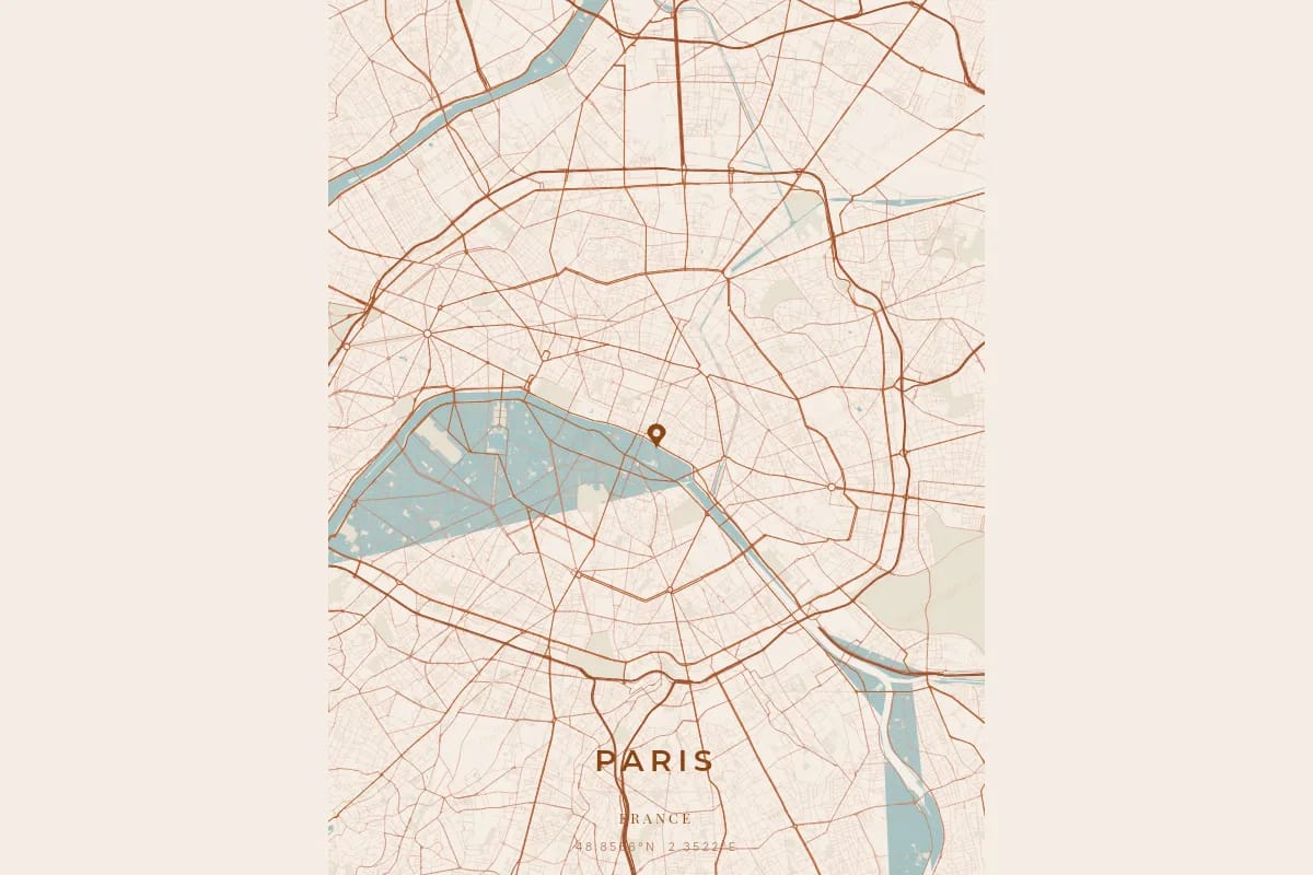
1. Paris — The Spiral of Arrondissements
Paris offers what may be the most recognisable city map in the world. Its twenty arrondissements spiral outward from the heart of the Ile de la Cite, creating a snail-shell pattern found in no other capital. The Seine draws two majestic curves that divide the city into Left Bank and Right Bank. The grand Haussmann boulevards radiate like stars from the great squares — Etoile, Nation, Bastille — while the narrow lanes of the Marais and Montmartre add a dense medieval texture. The contrast between these scales produces a poster of rare visual complexity.
Recommended theme: Noir — white streets on a black background evoke the classic engravings of the French capital.
2. Lyon — The Confluence of Two Rivers
Lyon is a city of confluences. The Rhone and the Saone meet at the southern tip of the Presqu'ile, creating a spectacular triangular point on the map. Old Lyon, pressed against the Fourviere hill, draws a tight web of narrow medieval streets that contrasts with the regular grid of the Part-Dieu district. The traboules — covered passageways running through buildings — are not visible on the map, but the streets connecting them form a remarkably dense network. The recently developed Confluence district adds modern lines to this urban palimpsest.
Recommended theme: Midnight Blue — the two rivers stand out beautifully against this deep background.
3. Bordeaux — The Perfect Arc of the Garonne
Bordeaux owes its cartographic beauty to the near-perfect curve the Garonne draws as it flows through the city. This arc, known as the Port de la Lune (Port of the Moon), gave the city its crescent-shaped coat of arms. The left bank displays symmetrical, orderly 18th-century urban planning, with wide avenues converging on the Place des Quinconces. The right bank, more recent and organic, creates a striking textural contrast. The broad quays lining the river add a clean border to the composition.
Recommended theme: Warm Beige — the warm tones recall the blonde stone of Bordeaux's facades.
4. Annecy — The Lake and the Old Town
Annecy is a unique case: the perfectly drawn northern shore of the lake enters the city map and creates a natural boundary of rare elegance. The old town, crossed by the Thiou river and its canals, forms a dense core of narrow streets that contrasts with the modern avenues. The surrounding mountains compress the urban fabric along the lakeshore, producing a long, slender city whose cartographic silhouette is instantly recognisable. The lake itself, empty of streets, provides a visual breathing space that highlights the urban pattern.
Recommended theme: Ocean — the deep blues pay tribute to the purity of the lake.
5. Strasbourg — The Grande Ile and the Rhine
Strasbourg has a remarkable cartographic feature: the Grande Ile, encircled by the branches of the river Ill, forms a dense island core perfectly outlined on the map. This medieval centre, a UNESCO World Heritage Site, draws an oval of tightly packed lanes surrounded by water — a visually powerful motif. Beyond it, the German-era Neustadt unfolds wide avenues in a star pattern, a legacy of the imperial period. The proximity of the Rhine and the autonomous port adds geometric basins to the east. This layering of eras and urban styles produces a map of exceptional richness.
Recommended theme: Blueprint — the technical rendering highlights the complexity of the waterway network.
6. Nice — The Promenade and the Grid
Nice offers a striking cartographic contrast. The Promenade des Anglais draws a gentle curve along the coastline, bordering the Baie des Anges. Behind this coastal line, Old Nice forms a rectangular block of ultra-narrow streets, almost like a woven fabric. Further west, the modern city lays out a regular American-style grid. The Chateau hill, empty of streets, creates a triangular void between these two urban fabrics. The result is a map that reads like three cities in one, each with its own geometry.
Recommended theme: Sunset — the warm sunset tones evoke the light of the Cote d'Azur.
7. Montpellier — Medieval Meets Modern
Montpellier is a city of temporal contrasts. The Ecusson, its medieval core, draws an irregular oval of winding streets, hidden squares, and dead ends that resembles a fingerprint on the map. Around it, the 19th-century extensions and modern districts — Antigone, Port Marianne — deploy radically different geometries: straight axes, neoclassical squares, and artificial basins. This juxtaposition between the organic chaos of the centre and the rigorous order of the newer extensions produces a map poster with a rare visual contrast.
Recommended theme: Terracotta — the warm tones of southern France harmonise with the medieval texture.
8. Nantes — The Arms of the Loire
Nantes is a city of islands and river branches. The Loire splits into several channels that historically divided the city into island districts. The Ile de Nantes, at the heart of the map, forms an elongated lens shape ringed by water — an instantly legible motif. The medieval city centre, on the north bank, spreads a dense network around the Chateau des Ducs de Bretagne. The former river channels, now filled in, have become boulevards that preserve the river's memory in the street pattern. This hydrographic complexity gives the map a remarkable visual depth.
Recommended theme: Forest — the deep greens evoke Nantes' parks and the city's verdant character.
9. Toulouse — The Bend of the Garonne
Toulouse stands out for the pronounced bend the Garonne makes as it crosses the city. This turn creates an asymmetry that energises the cartographic composition. The right bank displays a dense historic centre, structured by the Roman grid of the ancient city, still traceable beneath the medieval street pattern. The Canal du Midi, crossing the city to the east, adds a perfectly straight line as a counterpoint to the river's meanders. The pink bricks may not show on the map, but the wide squares — Capitole, Saint-Sernin, Wilson — punctuate the urban fabric with regular voids.
Recommended theme: Copper Patina — the coppery tones recall the pink brick facades of the Ville Rose.
10. Aix-en-Provence — The Radial City
Aix-en-Provence presents a radial structure clearly visible on the map. The Cours Mirabeau, a wide avenue lined with plane trees, cuts the city in two: to the north, the Vieil Aix fans out with medieval streets radiating from the cathedral; to the south, the Quartier Mazarin displays a regular 17th-century grid. This duality — organic to the north, orderly to the south — creates a sharp visual fault line. The ring boulevards, traced along the former ramparts, draw an oval that elegantly contains the whole.
Recommended theme: Pastel Dream — the soft tones evoke Provencal refinement.
Create an Aix-en-Provence poster
11. Lille — The Compact Star
Lille surprises with the compactness of its historic centre. The former Vauban fortification trace has left a star-shaped imprint that the modern boulevards still draw on the map. Inside, the Vieux Lille forms a tight knot of narrow Flemish streets, almost like a textile seen up close. The Citadelle, a perfect pentagon to the northwest, adds a strong geometric motif. The contrast between this military geometry and the organic disorder of the lanes creates a poster that balances rigour and complexity.
Recommended theme: Monochrome Blue — the single-tone sobriety highlights the geometry of the fortifications.
12. Rennes — The Medieval Centre and Channelled Canals
Rennes has a dense medieval centre, rebuilt after the great fire of 1720 on a partially rationalised plan. The result is a fascinating hybrid: regular 18th-century blocks pierced by surviving medieval streets. The Vilaine, channelled and covered in the centre, creates an unexpected straight line in the middle of the urban fabric. The Ille, which joins it to the east, adds a second water line. The large parks — Thabor, Gayeulles — provide empty spaces that lighten the density of the street pattern and give the poster room to breathe.
Recommended theme: Emerald — the greens evoke the lush character of the Breton capital.
13. Grenoble — The City Between Mountains
Grenoble offers a unique geographic setting for a map poster. Nestled at the confluence of the Drac and the Isere, between the Chartreuse, Vercors, and Belledonne mountain ranges, the city can only expand in the directions the terrain allows. The result is a constrained urban form, stretched along the valley, whose boundaries are dictated by geography rather than planning. The Isere draws a wide curve to the north of the city, and the Drac an almost straight line to the west. The density of the old centre, wedged between these two rivers, contrasts with the activity zones stretched along the valley.
Recommended theme: Japanese Ink — the spare sumi-e style evokes the mountain setting.
14. La Rochelle — The Old Port and the Islands
La Rochelle owes its cartographic singularity to its coastal location and its links to the islands. The Old Port forms a clean notch in the coastline, creating a natural focal point on the map. The historic centre organises itself in a semicircle around this port, with a dense network of arcaded streets. The bridges and viaducts connecting the city to the Ile de Re add fine lines extending out to sea, creating an unusual depth in the composition. The indented coastline, marshes, and marina basins enrich the map with varied textures.
Recommended theme: Neon Cyberpunk — the luminous contrast highlights the coastline and the island connections.
15. Avignon — The Walled City
Avignon is one of the few French cities whose ramparts are entirely preserved. On the map, this enclosure draws a perfectly legible rounded rectangle enclosing a medieval urban fabric of extreme density. The Rhone, flowing along the ramparts to the west, adds a wide band of water. The Ile de la Barthelasse, facing the city, creates a vast void that contrasts with the saturation of the walled centre. The famous Pont Saint-Benezet, even in its truncated state, leaves a trace on the map: a line reaching into the river and stopping abruptly.
Recommended theme: Contrast Zones — the contrasting zones highlight the sharp boundary between the dense walled centre and the river void.
How to Choose the Right City
Choosing a city for a map poster is first and foremost an emotional decision: you pick the city where you lived, fell in love, studied, or grew up. But if you are torn between several cities, here are four cartographic criteria to consider.
The presence of water. Cities crossed by a river or bordering a lake consistently produce more dynamic posters. Water creates voids that give rhythm to the composition and curves that break the rigidity of the built environment. Lyon, Bordeaux, and Annecy excel on this criterion.
Textural contrast. Cities that combine a dense historic centre with airy modern extensions offer superior visual richness. Montpellier, Toulouse, and Nice are ideal for this.
Overall shape. Some cities have a silhouette recognisable at first glance: the spiral of Paris, the star of Lille, the rectangle of Avignon. These strong shapes work particularly well in large formats.
The right theme. Every city has a character that the right theme reveals. A coastal city in Ocean, a Provencal city in Pastel Dream, an industrial city in Noir. Browse the 17 available themes in the design editor to find the perfect match.
Create Your French City Poster
Each of these 15 cities is available in our editor. Enter the city name, choose your theme, customise the typography and text, and preview the result in real time before ordering. The poster is available as a high-resolution digital download or as a premium print.
Frequently Asked Questions
Can I create a poster of a city not on this list?
Yes. The OwnHomeMap editor works with any city in the world. The 15 cities featured here are those with particularly spectacular street patterns, but all French cities — and international ones — are available. Simply enter the city name in the editor.
What size should I choose for a city map poster?
The size depends on the intended use. For a living room wall display, A2 or 18x24 inches delivers strong visual impact. For a study or bedroom, 16x20 inches or A3 is a good compromise. For a gift, the digital format lets the recipient choose their own print size.
Can I customise the text on the poster?
Yes. Every poster can be personalised with a main title (typically the city name), a subtitle (country, region, or coordinates), and a personal message. You can also choose from several fonts and adjust the layout in the design editor.
Ready to capture your special moment?
Create a personalized city map poster in minutes.
Create my poster — from €12.00